
Restricted Security Area Quanergy Surveillance Plugin
The seamless integration allows Quanergy's Q-Track to send actionable insights in the form of hyper-accurate alarms/events as well as object location to the Genetec RSA system. It also enables object tracking (camera slew to cue) by proving 3D situational awareness with wide coverage and high accuracy.
Jump to
Industry
- Cities
- Energy Utilities
- Public Safety
- Retail
- Sports Entertainment
- Transit
- Cannabis
- Corporate Campuses
- Data Centers
- Education
- Financial Institutions
- Gaming
- Healthcare
- Government
- Traffic
Restricted Security Area Quanergy Surveillance Plugin Solution Overview
The seamless integration allows Quanergy's Q-Track to send actionable insights in the form of hyper-accurate alarms/events as well as object location to the Genetec RSA system. It also enables object tracking (camera slew to cue) by proving 3D situational awareness with wide coverage and high accuracy.
Main Features:
- Object detection, tracking, classification at 98% accuracy
- Mesh architecture (stitch sensors for virtually unlimited coverage)
- PTZ camera slew to cue action
Key Market Applications
Critical Infrastructure customers deal with a high degree of false alarms leading to alarm fatigue and missed real alarms.
Quanergy’s 3D LiDAR based solution provides hyper accurate insights in the form of object detection, tracking, classification, speed, direction, and geolocation.
This ensures that Quanergy’s RSA solution is able to reduce the false alarms by 98% and allow the customers to focus their attention on what matters most.
Features & Benefits
- 360 degrees 3D coverage
- 140m range (diameter) per sensor
- >98% accurate detection and counting
- >95% accurate tracking and classification
- Continuous Tracking and Mesh Architecture
- Best in class horizontal angular resolution
- Bandwidth per sensor: ~25 Mbps
- Simultaneous tracking of 1000 objects/server
- POE+ Enables Plug and Play Deployment
- NDAA, BAA, GDPR, No PII
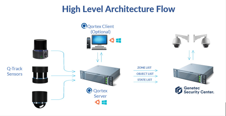
Solution Architecture
The Q-Track 2.3 system architecture deploys in a simple distributed scenario that includes the Qortex server and a QORTEX client or third-party application to consume the server output. • The server software interfaces with statically installed LiDAR sensors and produces output to your own network infrastructure, including a real-time list of tracked objects accessed through the QORTEX API.
Configuration and control of the server software are achieved through the client interface. The client software enables control and creation of a location (area of interest), with visualization of the corresponding server output point cloud, detected objects, tracks, classification, zones, and counter lines. Any number of potential third-party host infrastructure applications may subscribe to published data stream outputs for surveillance or visualization. The solution is a cpu based architecture and can be virtualized.